
Walk a Manatee Street Record
A sound by-street search uses one record to supply the key for the next. The Manatee County Property Appraiser ties a situs address, meaning the physical site, to a parcel and named owner. The county Property Locator then shows nearby parcels and boundary layers. A recorded deed can identify the buyer and seller, while permits and code cases can date work and name contacts. None of those facts alone proves who sleeps at the address today.
- Enter the street number and name in the Property Appraiser search. Save the parcel ID, situs address, owner name and legal description.
- Open the county Property Locator and select the parcel. Inspect adjacent lots, municipality, subdivision, ZIP and district layers.
- Use the owner and legal description in the Clerk's Official Records index. Read the acquisition deed before following earlier sellers.
- Check Accela permits and code cases by their split address fields. Repeat the search with the city custodian if the site is municipal.
- Use voter data only through lawful access, and consult verified historical directories when the question concerns an earlier household.
This sequence keeps a Manatee County street directory search anchored to public evidence. Save instrument numbers and book/page references, not just browser links, because interfaces can change.
Search Manatee Streets by Parcel
The Manatee County Property Appraiser updates its search data nightly. Quick Search accepts an owner name, street address or parcel ID. Searches are exact unless a trailing asterisk is added, so a partial street query needs that wildcard. Full Search can combine criteria, select result columns, narrow returned rows and export several formats.
| Search control | Input | Practical use |
|---|---|---|
| Owner Name | Last and first name | Exact by default; add a trailing asterisk for a prefix |
| Situs Address | Number and street | Find the physical property, not the tax-mail destination |
| Parcel ID | County parcel number | Reopen one known parcel without relying on spelling |
| Map and Narrow Results | Map or returned grid | Browse when the precise identifier is unknown |
| Export | Selected result fields | Available as Excel, CSV, PDF or mailing-label output |
The official property search tips explain the wildcard and result tools. The screen below shows the county's own instructions rather than a third-party address index.
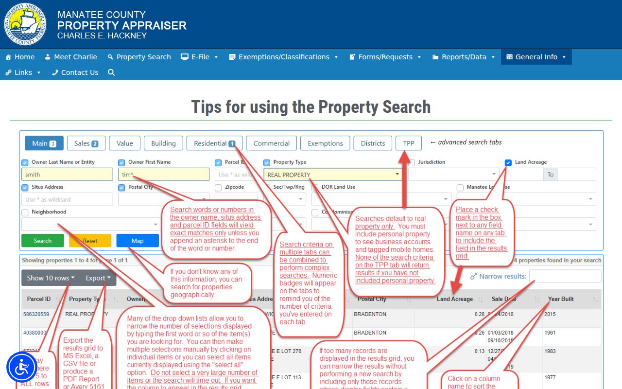
A broad street search can return multiple parcels, but each result still describes assessed property. It is not a current household roster.
Read a Manatee Parcel Card
A parcel card links the street directory inquiry to land identity. It can show owner names, situs and mailing addresses, lot or block, subdivision, acreage, land use, assessed values, building details, exemptions and sales. A parcel is a mapped unit of land. Its legal description remains useful even when a postal address changes.
The representative public parcel card illustrates how those fields appear together.
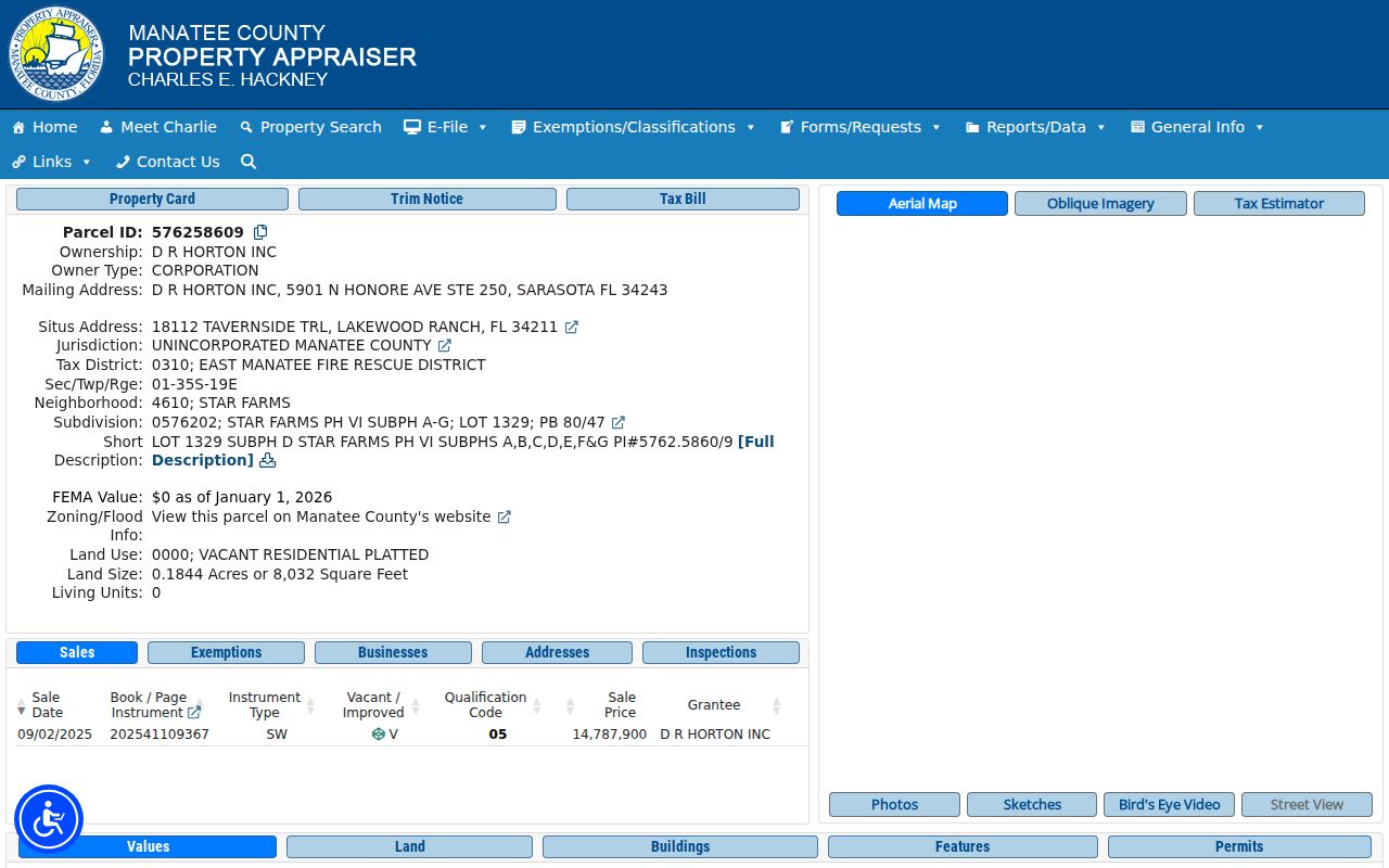
Read the mailing address with care. It is where the owner directs tax correspondence. It may differ from the situs address and does not identify renters, relatives or every person at the site.
Three different facts. Owner mailing address, property situs and household occupancy are not interchangeable in Manatee County records.
Map Manatee Streets and Boundaries
The Manatee County Property Locator adds spatial context. Search by address or parcel name and number, then select nearby features by shape, value or spatial relation. The Parcel layer supports a partial primary-address query. Point tolerance and a buffer measured in feet help capture nearby lots.
GIS attributes include subdivision, lot and block, section-township-range, municipality, property ZIP, historic district, flood and evacuation zones, school and fire districts, sale fields and year built. The service limits a single query to 2,000 records but supports pagination. That makes it useful for bounded research, not proof that every row names a resident.
- Parcel
- A mapped land unit with a county identifier.
- Situs address
- The physical location assigned to the property.
- Plat
- A recorded map that identifies subdivisions, lots, roads or condominiums.
- Criss-cross directory
- A historical directory arranged by street and house number rather than only by surname.
Follow Deeds Along Manatee Streets
The Manatee Clerk Official Records index covers January 3, 1978 forward. Search an owner as a grantee, meaning a buyer or recipient, then read the deed's grantor, legal description, recording date and book/page or instrument number. To move backward, search that seller as an earlier grantee and match the same land description.
Online images generally begin in 1981, but the Clerk's pages state slightly different start dates and list excluded books. Verify the individual instrument. Earlier indexes and deeds remain available through Public Access at the Historic Courthouse, 1115 Manatee Avenue West, Bradenton, Monday through Friday, 8:30 a.m. to 4:30 p.m., at 941-741-4040. A web gap is not a records gap.
Bridge Manatee Address Changes
Street numbers and postal labels are less durable than a legal description. When an old address stops matching, compare subdivision, lot and block, cross streets and recorded plats. Rural parcels may instead require section-township-range or a metes-and-bounds description, which defines land through bearings and distances.
The Clerk's Plat Records search covers subdivision, condominium, road and drain plats and includes date searching.
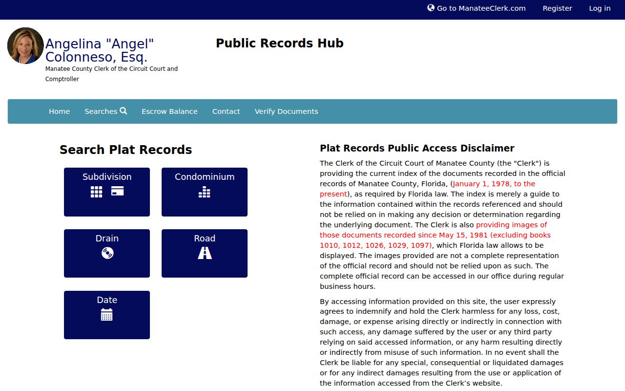
That recorded map can reconnect a modern parcel to an older deed or directory even when the street label has shifted.
Manatee Address Cases and Permits
County Accela records can name an applicant, contact, parcel, site, contractor, status and inspection history. The address form splits number, direction, street name, type and city. Matching is case-sensitive, and the date range must include the date a case was created. Record Detail, Processing Status and Inspections are separate result tabs.
The county's address-based code search instructions show the required format.
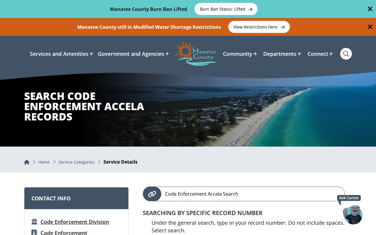
Development Services moved its counter to 9000 Town Center Parkway in Lakewood Ranch in late 2025. County Accela chiefly covers unincorporated areas, so a municipal address may require a second request to the city that created the file.
Manatee Street Records Compared
Each official source answers a different address question. The street directory chain is strongest when parcel identity, recorded title, map context and agency jurisdiction agree.
| Record Set | Keeper | What It Shows | Access |
|---|---|---|---|
| Property roll | Property Appraiser | Owner, situs, mailing address, parcel and improvements | Free web search, map and export |
| GIS parcel map | Manatee County GIS | Nearby parcels, boundaries, ZIPs and districts | Free viewer and open service |
| Deeds and liens | Clerk Recording | Recorded parties, dates and legal description | Web index; counter for older material |
| Voter record | Supervisor of Elections | Individual registration data with protected fields removed | Own-record lookup or lawful file request |
| Permits and code | County or municipality | Application, site, contacts, status and inspections | Accela, counter or Chapter 119 request |
If a portal fails, use the documented fallback. County department records can be requested online, by phone, in writing or in person. Deeds and court material go to the Clerk, parcel files to the Property Appraiser, and municipal permits to the relevant city. Florida Chapter 119 covers existing nonexempt records, but an office need not create a custom street list or perform research.
Bradenton Streets Beyond City Limits
A Bradenton postal label can describe an address outside the City of Bradenton, including parts of Lakewood Ranch. Anna Maria Island is divided among three municipalities. Longboat Key crosses Manatee and Sarasota counties. Permits and code cases follow the government with jurisdiction, while deeds, assessments and courts follow the parcel's county.
Postal city, municipality and county are separate geography. Confirm all three before choosing a custodian. The address-level result matters more than assumptions drawn from the ZIP label.
Note: Coastal owner-mail addresses often reflect seasonal correspondence and are especially weak evidence of current occupancy.
Manatee Voter Data by Street
The Supervisor of Elections web form is an individualized verification tool, not a public street browser. It requires first name, last name, birth date, an agreement checkbox and later street-number verification. Do not scrape it or describe it as a directory of neighbors.
A lawful voter-file request may include public fields such as name, residence or mailing address, status, precinct and election participation history. Ballot choices remain secret. Signatures, full identifying numbers and protected addresses are excluded under Florida law. When the goal shifts from one address to historical occupants, use the Manatee County city directory collections instead of forcing a current voter tool into that role.
Limits of Manatee Street Records
No Manatee County street directory source gives a complete household list. Assessment and deed files usually name owners, not all occupants. Homestead is an owner-occupancy clue at a statutory point, not proof of every resident or a move-in date. A permit date shows work, not when someone arrived. Voter data omits people who are not registered and protects specified fields and addresses.
Motor-vehicle personal information is restricted, and utility-account data should not be treated as a public directory. Florida's Address Confidentiality Program and other statutory exemptions can replace or hide qualifying addresses. Absence from a portal may therefore reflect privacy, record coverage or jurisdiction rather than absence from Manatee County.
Lawful use. Use Manatee County address records for lawful personal research. Public access never permits stalking, harassment, threats or harm.